Wednesday 5 July 2017

Climbing Great Gully Ridge

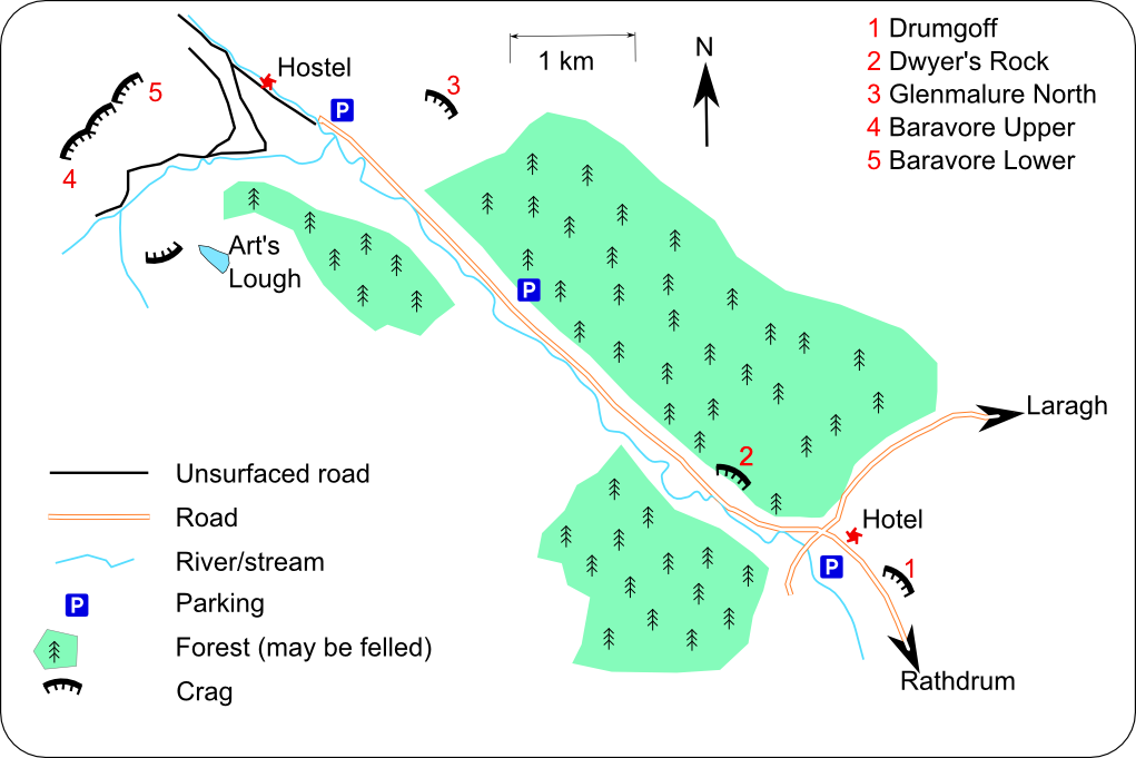
Great Gully Ridge on Ben Leagh from walk in
On the nasty gorse sinkhole walk out we bumped into a lad who asked what I did on the top pitch, did I do the crack with the piton? I described to him. gesturing with my hands, taking the first crack, getting in a good #3 nut, stepping up into this barn-door bridge-ish feet with my left-hand, bottom fingers turned sideways, slotted under a hidden crack and my right arm pulling on an edge, moving my left foot up a bit and then moving my left hand up expecting an edge but only finding slopers...not enough for me to hold and jump my right hand up...climbing as we know it!

A perfect day! The couple of mistakes I made were inconsequential in the end. The plan was to meet at the car park for Baravore Valley at 8.30. I had not organised buying an OS map for the area and had the WhatsApp directions from a friend in my head "turn right into Glenmalure having travelled down the Old Military Road from Laragh". I left 10 minutes later than planned and arrived in Laragh at 8.30, as I came in I saw a brown sign for the old military road kind of half going to the right outside the Glendalough Green cafe. I pulled up and asked the waitress, who was just starting to say "we don't have...", was that the Old Military Road, pointing to the right. She said "Yes, thanks a million", no doubt relieved I was not jonesing for coffee, as she gripped her first smoke.

So I headed up the road, passing the first big lay-by after a few minutes where there were some cars stationed and I could see tents in the trees. The road kept going and going, a couple of hikers, more campers, a cyclist - a perfect road for that. Another 10 minutes and there was a lad at the back of his car with the hatch up, I rolled up and popped the question. "You are on the wrong road mate, this goes to the Sally Gap, head back down to the crossroad, turn right back into Laragh, past Lynhams, then turn right and follow the Glenmalure sign". Military road my ass, 30 minutes lost.

Glenmalure is a u-shaped glacial valley in the Wicklow Mountains in eastern Ireland, 250m higher than Glendalough, with this being the one road leading in or out, I turned right at the Drumgoff crossroads, with Glenmalure Lodge on the left, and took the road to the end where the Baravore Car Park was unexpectedly large. We left the car park at 9.40 having figured we walked up past the hostel. The warden was out in the garden and we queried about accessing Great Gully Ridge? "Keep on going, head up to the left, there are 2 lads ahead of ye", he called out, as we kept moving. This was useful when a couple of minutes later the road swung to the left with a path going on ahead.

So warm already, a guaranteed cracker of a day under the precious high-pressure spell. As we walked in the unsealed road into the heart of the Fraughan Rock Glen, another name for the valley, Colm told us about Michael Dwyer, who was a captain in the United Irishmen Rebellion of 1798. The area around us was a stronghold for rebels against the British due to its remoteness and inaccessibility but also relative closeness to Dublin. He held out for years in the hills with the British attempting to deny him shelter by severely punishing those suspected of harbouring his men. They assigned thousands of troops to Wicklow, and built a series of barracks as well as the aforementioned military road! Eventually, a deal was made but the British reneged on an agreement to give him safe passage to America and he spent 18 months in Kilmainham jail before he was sent to Australia as an unsentenced exile in 1805. However, he was stripped of his free settler status and transported to Van Diemen's Land (Tasmania). In 1808 the Governor of New South Wales ordered that Michael Dwyer's freedom was reinstated. Amazingly, Michael Dwyer was later to become Chief of Police (1813–1820) at Liverpool, New South Wales.

As the road progressed into the valley it became more and more obvious that our route was up in the right corner, a relief with the left side in shade somewhat. It's marked  Baravore Upper in the climbing.ie guide. As the unsealed road ended it was clear we need to cross the rough ground towards the base of the ridge, there was a slab with some water trickling down it that's better to cross lower than higher. We were at the base of the route at 11.00.


The route is HS, 4 pitches of 4a,3c,4b,4a and is described as 140m long on the climbing.ie route wiki. The system for grading traditionally protected climbs in Ireland is the traditional, two-part British \ Irish grade, a combination of the adjectival and technical grades. From the BMC site: "The adjectival grade [HS - Hard Severe] is the first part of the grade, and attempts to give a sense of the overall difficulty of a climb. This will be influenced by many aspects, including seriousness, sustaindness, technical difficulty, exposure, strenuousness, rock quality, and any other less tangible aspects which lend difficulty to a pitch. The second part of the grade, the technical grade [4a, 4b], is there to give an indication of the hardest move to be found on the route, irrespective of how many of them there might be, how strenuous it is, or how frightened you are when you do it." Comparing this to the USA where they have a single grade, the route is 5.6 from my experience.

David Flanagan's book Rock climbing in Ireland has a topo of the route and he has made these available: longer topocloser topo. We used the former for route finding:
Dave Flanagan's Topo
I lead all the pitches, bringing 2 ropes, with Colm coming second cleaning the gear and Dave following third bringing the backpack. We only used one of the ropes for leading\belaying. I did clip one or 2 pieces into the 2nd rope to protect Dave when there was some traversing and he was being belayed on that rope. I ran out the 2nd pitch but still needed a 3rd scrambling pitch to set up a belay at the grassy wall described for the last pitch.

Tom on 2nd pitch

As we moved up the wall Art's Lough came more into view and the gorgeous weather made the thought of swimming across it all the more appealing.

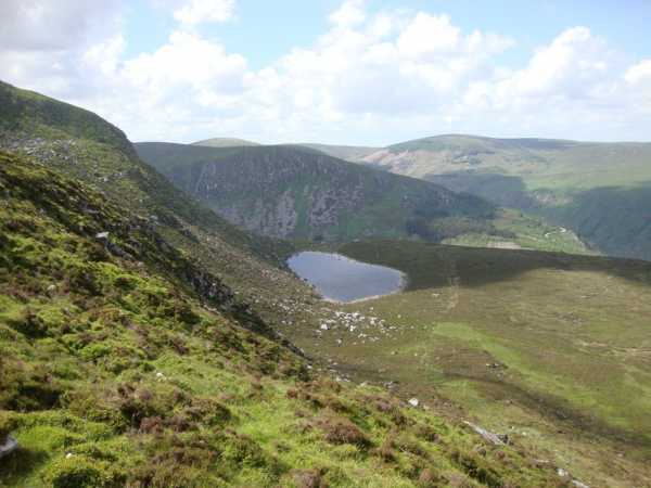
Art's Lough from Great Gully Ridge
Taking snaps along the route got me thinking of a problem I never had climbing in the 90s and the first half of the naughties, what's a solution for carrying a camera phone when climbing? For multi-pitches, I used a small camera bag in the past clipped to my rack, but the camera always had a strap. Maybe a phone loop is an answer?

Dave & Colm on route
Dave Flanagan's 2012 blog on the route, describes three cruxes which are spot on, the first being literally at the start. I agree there is plenty of gear for all the cruxes. The exposure on the last pitch is outstanding and I wished it just kept going but it ended all too soon when another perfect belay spot materialised. There was about another 50m scramble up some grass, if you were to contine to the ridge top.

Colm found the abseil chain, I double-fishermaned the two ropes together and tossed them towards the narrow grassy gully. I ended up coming down a clean buttress, which must be the headwall area, it has a couple of 20m star VSs (D-for-Dog & Z-Backwards), which looked about right from abing down. The 50m rope barely got to the gully on the stretch. The orange rope would not pull! No tricks would get it loose. So it was out with my prusik to self-belay climbing up the corner. The 4 pm sun was catching us now and without a head scarf under my helmet, the sweat was literally streaming in rivers into my eyes, as I bridged up, with the sun block burning them as a result. I had to keep my eyes closed tight and trust those feet, feeling the prusik inching up. It's always great to have a reference and mine was The Maiden in Boulder's Flatirons in 1995 and having to "Kill the fear" and jumar with prusiks up a hanging free rope in the dark in order to free what ended up being a knot jammed on the other side of the lip. This time, it was easier, I reached a grassy bank and was able to traverse over to where I was above a point I passed between on the 2nd  pitch where I knew there was another abseil point. I figured the rope had to pull from there and it did with some effort.

Great Gully Ridge looking down route
So talking to the lad we met walking out, I pulled out of my climbing gestures and said, yep, I backed off and climbed the crack with the old piton in it! It was exposed but felt very solid in comparison to the first crack 😀 The lads said most people go that way! Reading the UK Climbing log, one climber says the first crack is a VS finish, which feels about right for my rusty climbing skills, a good edge for liebacking he says...hmmm, not sure about that part! This lad still had another 15 minutes slog to the base, he had two women with him and he was leading having done the route a few time before. He was going to walk down via the head of the glen near the watercourse. It was 6.30 and he had a solid 4 hours of light left, you can't beat Irish summer evenings!

We were out of water! Colm gave me the last 10ml when I got down after the abseil saga. I was well thirsty after all that! My reference was a summer day in Eldorado Canyon with Matt, perhaps my favourite crag to climb in the world, getting down and driving to a gas station and drinking a straight bottle of Gatorade! I think this was worse! On the ridge, we had spotted the 2 climbers ahead of us cutting directly from the base to the road and we followed suite. Clearly, there is no path through and with the vegetation at a mid-summer high, it was not possible to avoid sinkhole drops in the gorse. Not an escape to the road to remember, most definitely climb with all your gear and walk out via the watercourse after you top out on the ridge and walk down to where it drops into the valley. Next time I would also walk in the same way we did, taking the road to the end.

Gorse walk-out marked - it does not look so bad from a height!
We called into the hostel desperate for water - it's pretty much is a simple Mountain Hut, with no running water or electricity. We could hear the Avonbeg River flowing at the back of the hostel and see their stack of 5L Bottles in the kitchen. The volunteer wardens very kindly brought us out some glasses, I drank 5 straight. They told us the hostel is now open in the summer months and every weekend through the year, staffed by volunteers.

The hostel was originally built as a hunting lodge and key historical Irish figures have spent time there, Countess Markievicz, Maud Gonne and her son Sean McBride, a founding member of Amnesty International and Nobel Peace Prize winner. Of course, Maud Gonne was W.B. Yeats's Muse, so Yeats also visited. J.M Synge owned the estate at one point and he wrote a play which was set in the house. It also hosted Irish presidents Eamon De Valera and Erskine Childers. It was donated to An Oige in 1955. The climbers ahead of us had stayed at the hostel the night before, an ideal choice for getting a proper early start on the route.

The Glenmalure Lodge was a perfect stop before the 2-hour drive home and this was my order for myself! A new reference point for thirst!

Friday 23 June 2017

Mizen to Malin 2017


Night 1: Leg 1: Mizen to Schull


Day 1: Leg 2 Schull to Tralee


Kevin 12:21

Kevin 00:22

Tough enough day today. 140km to Tralee. 5.5 hours saddle time, but over 8 hours from start to finish. Lovely weather, lovely scenery. Two significant climbs, Caha pass and molls gap, but each of those is not steep and fairly steady. Just long. While 6 of us did a longer spin two weekends ago, we all felt grand after it. Made us all think we were sorted. But, same guys, me included, have fairly sore tired legs after today...not good!

Not a whole lot of craic after dinner tonight... Lots off to bed early, those that stayed were pretty quiet.

175km planned tomorrow to get to Galway, so it's new territory there. Must go to bed!


Day 2: Leg 3: Tralee to Galway

Kevin 08:06 

Heading out soon, heading for the ferry!

Kevin 16:05
Galway bay
Kevin 16.10 

Gorgeous... That cycle from Lahinch to here in Kinvara [inland] was one of the best ever...

Conor 22:09

Good day today. Left Tralee at 8:30 and were well on target for the ferry at Tarbert at 10:30. A puncture for one of the two lads with disc brakes meant it had to be fixed so we barely made it. Got off at Killimer and headed for Cooraclare and to Quilty. It was Wild Atlantic Way to Lahinch from there with a good breeze behind us. Lunch was at one of the lad's mother's house. We were of again by 2:00 and made our way through mid-Clare, Ennistymon, Kilfinora, etc to end up in Kinvara by 4:00. Time for a pint and we rolled out of there to Kilcolgan. From there it was a bit of a grind to Galway city and we arrived here at 5:40. 

Another big day awaits tomorrow!!


Preparation... And...nutrition! 😲

Day 3: Leg 4: Galway to Bundoran

Conor 20.10


Day 4: Leg 5: Bundoran to Malin

Conor 09:20
Getting there...
Conor

A few brief comments on yesterday's final stage. Kevin will have a different perspective as he is a fit as could be. 

The grand plan was to be in the road for 7:00 so that we would be finished by 3:00 - it didn't work out that way. The start was delayed to try and avoid rain but we were all fairly wet by the time we got to Donegal town. Barnesmore Gap was a grind but beautiful, even in poor enough weather. After the descent to Stranorlar and Ballybofey, the tone was set for the rest of the day as long drags started to feature - a killer after three long days (unless you are Kevin). In fact Kevin matched one of the Athlone dudes, Michael, whenever he felt like it. 

Ballybofey to Letterkenny was the worst of the weather so lunch at 10:45 was very welcome. Most lads did a near complete change of gear, especially top layers. Having that option highlighted the value of a support vehicle. From there to Buncrana was enjoyable as spirits were good. After coffee and the purchase of slabs of beer it was time to push on, on into a beautiful bog-land wilderness to Carndonagh. Sharon's sister, Michelle, gave us the lights as she passed us on the way to a call-out and Kevin had a lovely welcome from Maire and John McGeoghegan in Carndonagh who waited on the street to see us. 

The last leg was really scenic as the sun came out for us. We rolled along the coast before turning inland and up (some more) short steep ramps. Once we were within 5km we could see the tower at the headland so we pushed on in great spirits. One final push was needed to cover the last 500m as the road climbed steeply to the finish line at 4:20. I'm glad it wasn't a climb that I knew about as it was, at a guess, over 10% with a few bends at 15%. 

Cue great celebrations and relief and silly photos as we could finally say that the job was done. 
It sounds silly, but the return journey framed the achievement for me. I broke each day down into segments and tried to avoid the thoughts of long daily distances. It took a long time to get home and that's what made me realise, "Christ, this was a huge undertaking!" I got to bed at 2:30 but really glad to have knocked it off. I'm sore today, but the memories will live forever and the legs will be fine tomorrow.


The last few minutes of Mizen to Malin captured on Adrian's GoPro here! What a relief to get up that last steep little hill and see the painted "Start/Finish" on the ground! Kudos to all the team!

That's the elation at knocking it off! Bloody great day!
678 km, c. 5,500 m of vertical ascent.

Tuesday 30 May 2017

Amstel Gold sportive 2017


Amstel Gold sportive 
15 April 2017 
150km and 1,600m of climbing 
15,000 particpants 

Back from the Amstel, I survived, Kevin thrived. He was something else.

 Saturday didn't dawn well as gloomy early morning light was dappled with sporadic raindrops on the windows. The so-called Amstel Gold breakfast was inadequate, I doubt if it would have fortified a doggy for sitting in a window, let alone a body facing 7 hours or more on the saddle. We collected rented bikes from a warehouse and pedaled down to register. With all of that done, we rolled out at 9:30 in chilly, misty conditions.

The severity of the challenge became apparent as heavier showers punctuated the mist. With many parts of the route trailing through open upland meadows there was no shelter from a sometimes gusting but always present wind. The first foodstop came after 49 km, it was in a field that wouldn't look out of place in the ploughing championships. It was a low point as we stood around shivering while Redmond Burke fixed his second puncture. We literally had to get going before the cold paralysed is but some 30 mins later Redmond was fixing his third puncture. He eventually resolved the puncture trilogy and after we had completed two really good, even climbs we all met up again at the point where the borders of the Netherlands, Germany and Belgium meet. This social occasion included coffee, chips and Paul Quinlan warming his feet while trying to dry his socks at a very swanky open fire.

At that stage, with 82 km completed and a descent ahead I was feeling more optimistic. Little did I know that the sight of heaven and the finish was to require a further purgatory as short, jagged climbs with average gradient of 8% and ramps of double that signposted the closing 50 km. Kevin didn't put a foot down while I cracked and crumbled on three of them. In truth only one was a source of later reproach as I just can't do beyond 10%. Meanwhile Kevin crowned his day by passing multitudes in the Keutenberg, (the steepest hill in the Netherlands, average of 11% which begins with 22%.

We eventually came down into Valkenburg and swung left on to the iconic Cauberg hill, one last km at 7% with 12% shortly after it commenced. I was out on my feet but stayed in the saddle and ground it out. The last 1800m of flat was pure relief and a place that seemed so far away for so much of the day. After a quick beer we solved a transport issue by having some of us cycle back to Maastricht. I didn't care, it was a level road, one of the few I had been on that day.
Subscribe via FeedBurner